From empty fishing nets in Peru to early wildfires in Indonesia, the strongest El Niño in decades is throwing its weight around. Scientists say the rulebook written by past events may no longer apply. Off the coast of Peru, the sea usually gives generously. Those waters are among the most productive fisheries on the planet, turning out millions of tonnes of anchovies every year for fertiliser and animal feed. But in late August, the government pulled the plug on the season early.
The reason was floating right there in the water. The El Niño event gathering strength in the tropical Pacific had pushed ocean temperatures up, and the full grown anchovies had gone hunting for food in deeper, colder water. The nets came up light, and the season was called off. That is one story out of many. This year’s monster El Niño is already causing disruption around the world, and forecasters say the months ahead will be busier still.
El Niños come in flavours
An El Niño begins when sea surface temperatures in the tropical Pacific turn abnormally warm. That warmth heats the air above it, which in turn reshapes wind and weather patterns thousands of kilometres away. But not every El Niño behaves the same way. Events driven by warm water in the central Pacific play out differently from ones that form in the eastern Pacific, and strong events produce different weather from moderate ones. “El Niños come in flavours, like ice creams,” says Jérôme Vialard at the Research Institute for Development in Marseille, France.
This one has an eastern Pacific flavour, and according to Eran Vos, a climate scientist at Bar-Ilan University in Ramat Gan, Israel, it is the first strong El Niño of that kind since the late 1990s. That matters, because there is very little precedent for how it will behave after nearly three decades of extra global warming.
“You change the patterns and the weather reacts,” Vos says.
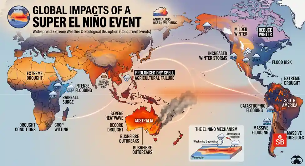
Drought in Central America has slowed shipping through the Panama Canal, which relies on fresh water to fill its locks for every ship that passes. Tens of thousands of smallholder farmers in Guatemala, Honduras and El Salvador have reported crop losses. In the Caribbean, an historic drought already worsened by climate change has tightened its grip, forcing water rationing in Puerto Rico and leaving crops stressed in Jamaica.
The same hot, dry pattern runs right around the equator. Indonesia has seen an above average start to its wildfire season, and India recorded a lower than average monsoon, even while flooding hit parts of the country, which is an expected quirk of El Niño years.
In parts of southern and East Africa, dry weather has collided with high fuel and fertiliser prices, and food security is taking the hit. A June report from the United Nations World Food Programme projected that tens of millions of people in these regions will face acute food insecurity because of the El Niño.
It also came out of the gate early, strengthening sooner than the famous events of 1997 and 2015. Some forecasts suggest it could end up as the strongest in centuries, and that stacked on top of global warming, it could push average global temperatures in 2027 to record levels. Where the taps are running dry
So far, the emerging effects look a lot like those of past strong events.
Where the rain will not let up
At the other end of the seesaw, some regions get far too much water. Heavy rain and snow in Chile and Peru have already caused flooding, disrupted copper mining and closed the Incan citadel of Machu Picchu to tourists. The Horn of Africa is expected to see flooding on a scale similar to the 2023 El Niño, which displaced millions of people.
Deepti Singh, a climate scientist at Washington State University in Vancouver, says extreme rainfall is also expected in the western United States and along the Pacific coast of South America.
The biggest question on scientists’ minds
Disruptions are likely to roll on through 2027 as the event intensifies. “The impacts, to some extent, scale with the magnitude of El Niño,” Singh says.
Climate change could alter those impacts in ways that are hard to predict. Some El Niño effects, such as heavier rain or higher temperatures, might simply stack on top of global warming and push extremes further.
“Will this event interact with climate change in a complicated way to produce impacts that are greater than the sum of its parts?” asks Christopher Callahan, an earth system scientist at Indiana University in Bloomington. “I’m not sure. But for me that is the biggest scientific question going into this event.”
Old maps, new atmosphere
A thornier question sits underneath all this. Climate change may be quietly redrawing the map of where El Niño makes itself felt. Scientists call these long distance links teleconnections, and there are signs they are shifting.Vos and his colleagues found that between 1960 and 1990, El Niños were linked with warmer temperatures in south Asia and northeastern Africa. Since then, the same events have been linked with cooler temperatures there. Over the same period, Western Europe flipped the other way, from cooling during El Niños to warming.
If the old patterns no longer hold, preparing for the next one gets much harder. “We know less about the teleconnections of the new atmosphere,” Vos says.
For the anchovy crews in Peru, the farmers in Guatemala and the families in the Horn of Africa, that uncertainty is not an academic problem. It is the difference between being ready and being caught on the back foot.
Sources:
Beniche, M., Vialard, J., Taschetto, A. S., & Lengaigne, M. (2026). Geophysical Research Letters, 53, e2025GL121189.
Dinneen, J. (2026, September 13). The super El Niño is already wreaking havoc: Here’s what’s in store. Nature. https://doi.org/10.1038/d41586-026-02826-5
Vos, E., Huybers, P., & Tziperman, E. (2026). Geophysical Research Letters, 53, e2025GL119307.